
Tags
Abandoned railways, History, London, Musings, Photography, Picture of the day, Railways, Railways History
The pair of us are having a local but active day here at Bigland Towers. Dawn’s been busy baking, experimenting with some cake and cookie recipies whilst I’ve been occupied in the office. I had a phone call on Friday afternoon that’s completely changed my plans for next week as it involves some commissions and COP26 so trips to Scotland beckon. Meanwhile, I’ve some articles to pen before I do, which means the week ahead’s going to be hectic.
As if that wasn’t enough, I’ve been trying to keep up the momentum on scanning old slides, which leads to today’s little picture story.
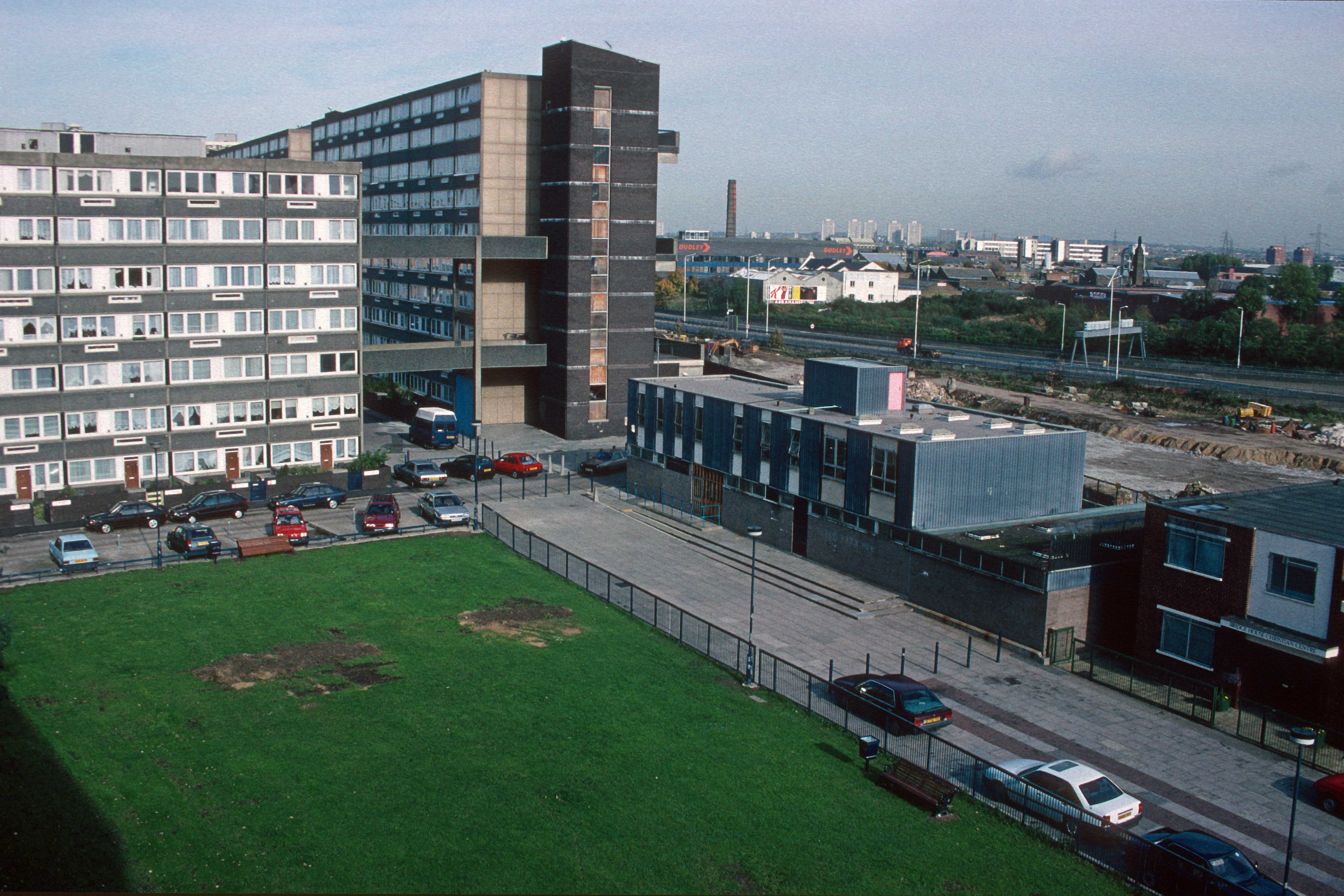
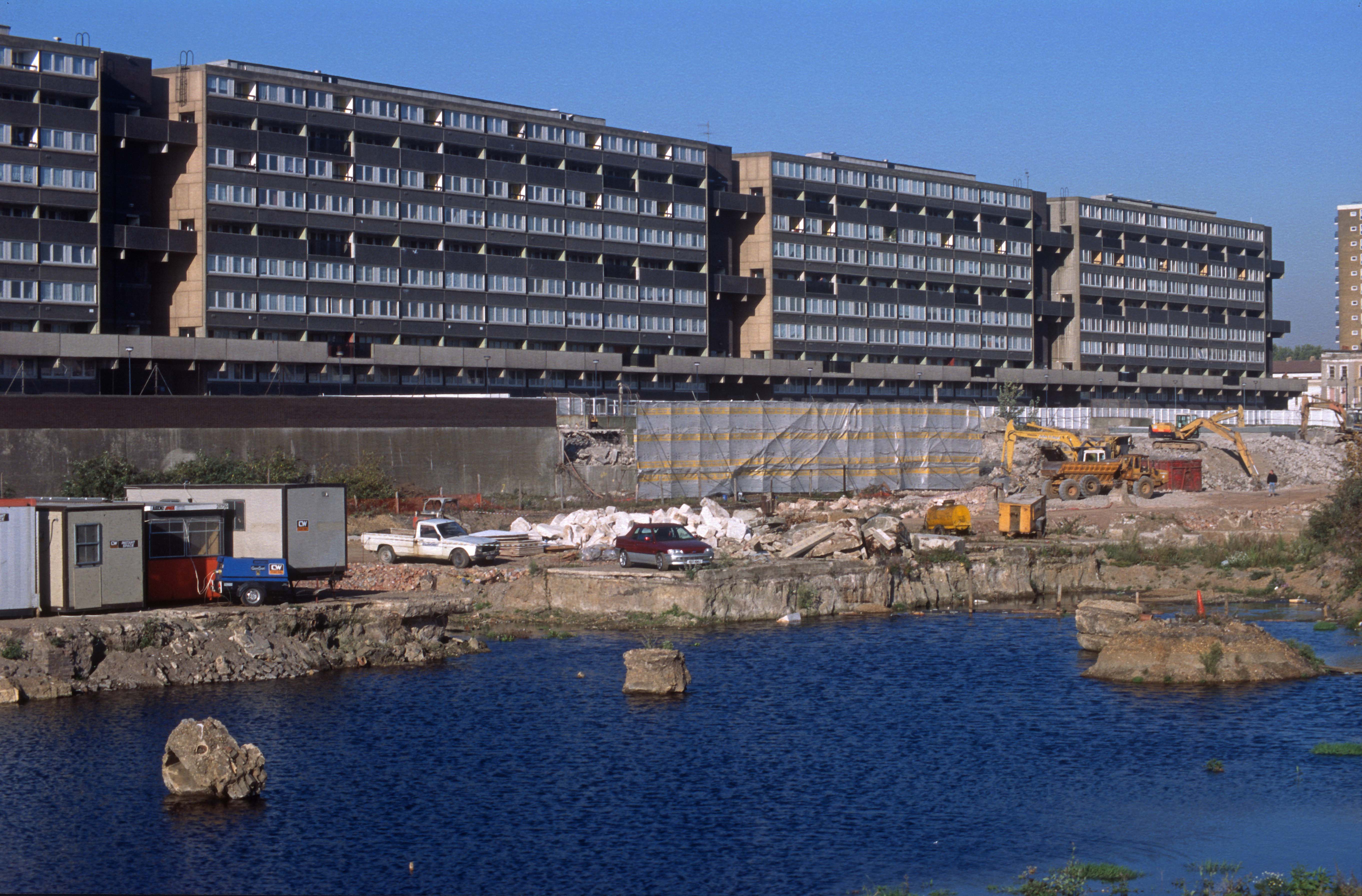
The latest batch of slides were taken in 1994 when I was working as a Housing Officer in Bow, East London. Having left my previous housing job in nearby Poplar (where I lived) to spend a year travelling solo in SE Asia I applied for a job with Bow neighbourhood, was accepted and offered a position as Housing Officer on the Lefevre Estate. The name sounded far better than the reality. The Estate consisted of a series of brutalist 1970s deck access maisonettes linked together by walkways. Our office, located on the estate, wasn’t much better. Even so, I really enjoyed working there. When I accepted the job I’d been told that the estate was due to be transferred to a new Government quango called a Housing Action Trust (HAT), one of only 5 in the country. This would manage the complete redevelopment of the estate and 2 others adjacent. I had the option of staying with the council and being transferred to another housing job on another estate or being TUPE’d across to the HAT when it was established. Being adventurous and liking what the embryonic HAT Management team told me about what to expect and the opportunities to broaden my skills that would be on offer, I decided to sign up.
This meant that I stayed on the HAT estates for the rest of my housing career. A decision I never regretted although I’d no idea at that time what my future career looked like. I could write a book about those times, but that’s not the purpose of this blog. Instead, I’m going to talk about something else – one of the railways of that part of the East End and the changing face of London.
Our office on Lefevre Walk backed onto what had been a scrapyard, but before that it had been a railway. The North London Railway. It had been a Southerly branch from what’s still the North London Line (now the Overground) running through Old Ford, Poplar and Bow down to the London docks. I moved to East London in 1986 so never knew this line when it was open as it had closed a couple of years before. In those last days it had been a freight only line although I could still see the remains of some of the old stations like Bow Rd which had all closed in 1944 due to enemy action.
Sadly, I never researched the route by getting any books on the NLR. Nowadays it’s so easy just to look stuff up on the internet, but not in 1994. So, whilst I knew that the old scrapyard outside my office window (known as Yallop’s Yard) had been an old railway goods yard I never knew at the time there’d been an old railway station on part of the site. In some ways that’s not too surprising. The area looked completely different as in the 1970s an urban motorway (the A102M) had cut a swathe through the old factories and homes in the Lea Valley. Here’s some of the pictures I took in 1994, then I’ll link to something that shows you how it used to look even earlier. To say you wouldn’t recognise it now is an understatement. I don’t recognise the 1950s photos. Today, if you visited the area, you wouldn’t recognise it from my 1994 pictures either!
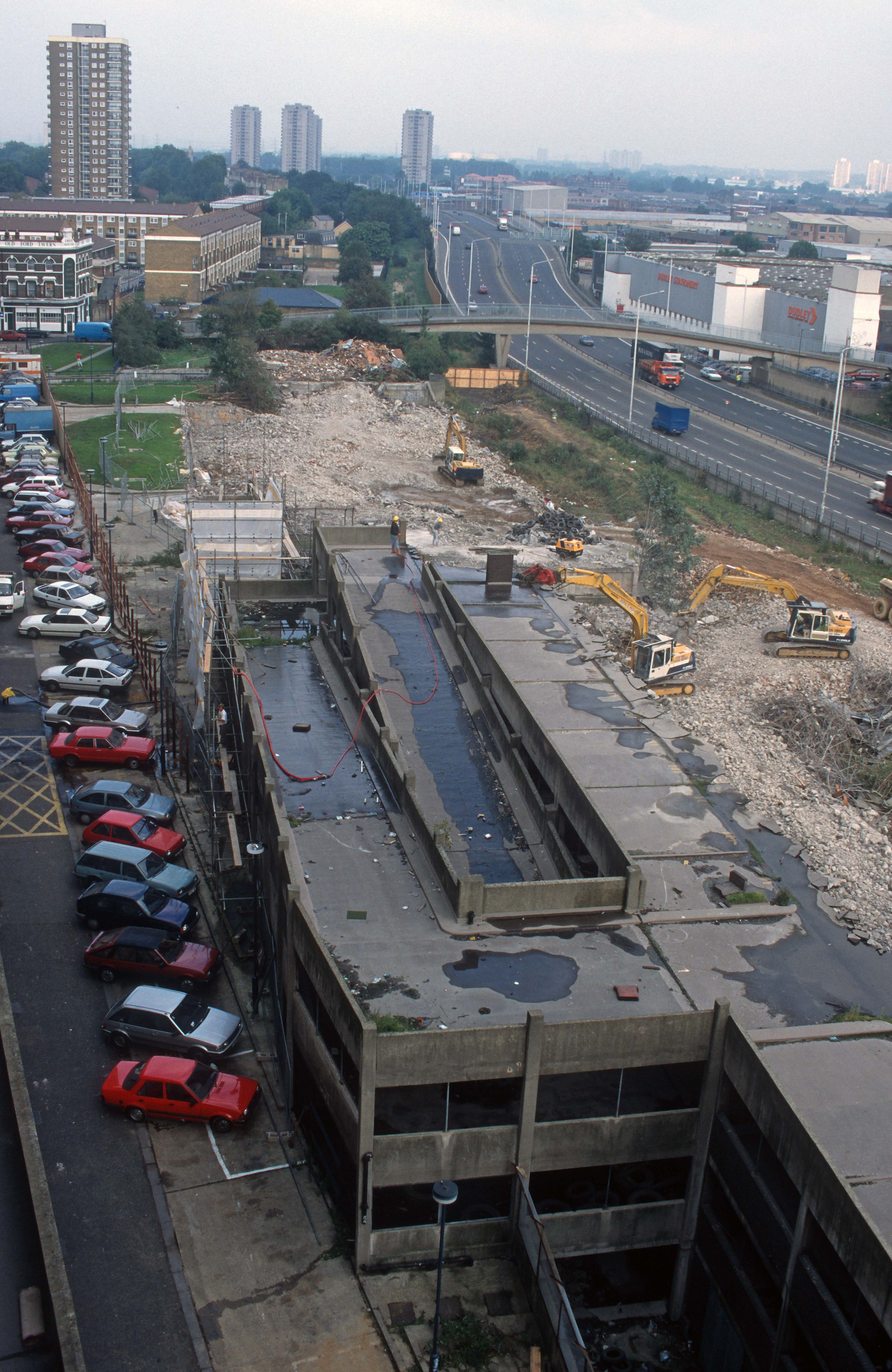
Here’s a zoom shot showing the course of the North London Railway heading South. The first bridge is where the Great Eastern main line crosses. The second is the link from the GEML at Bow junction to the former London Tilbury and Southend line to Fenchurch St at Gas Factory Junction. The NLR route had been converted into a linear park several years previously (at considerable expense) but was now being taken for housing as London’s population – which had been shrinking since World War 2 was suddenly expanding again. See the red roofed building below the tower blocks? If you look to the right you can just make out the platforms of Bow Rd DLR station.
Nowadays, with the advent of the internet, it’s easy to research images of what they area used to look like. The excellent ‘Disused stations’ website has the history of the railway and also some old pictures of the station and area. Even I was surprised by how the place used to look! Here’s a link to a look at a long-vanished part of London’s East End.
I’ve a favour to ask…
If you enjoy reading this blog, please click on an advert or two. You don’t have to buy anything you don’t want to of course (although if you did find something that tickled your fancy that would be fab!), but the revenue from them helps to cover some of the cost of maintaining this site – and right now (because of Covid), us freelances appreciate all the help that we can get to aid us in bouncing back from lockdowns. Remember, 99% of the pictures used in my blogs can be purchased as prints from my other website – https://paulbigland.zenfolio.com/
Thank you!

Hi,
I am attempting to build an archive to document life on Lefevre Walk Estate and the success and failures of this particular form of social housing.
would you be interested in sharing some memories and more photos if you have any?
i can be contacted directly or use facebook page link here:
https://www.facebook.com/profile.php?id=61554688846666
Any chance you can upload these on a website other than facebook? I don’t have an account (and refuse to make one as I don’t like what facebook do with private data). Had a fun time growing up in lefevre in the 90’s. As dirty, grimy and dangerous as it was, it had an unexplainable aura, charm and architectural grandeur that I’ll never forget.