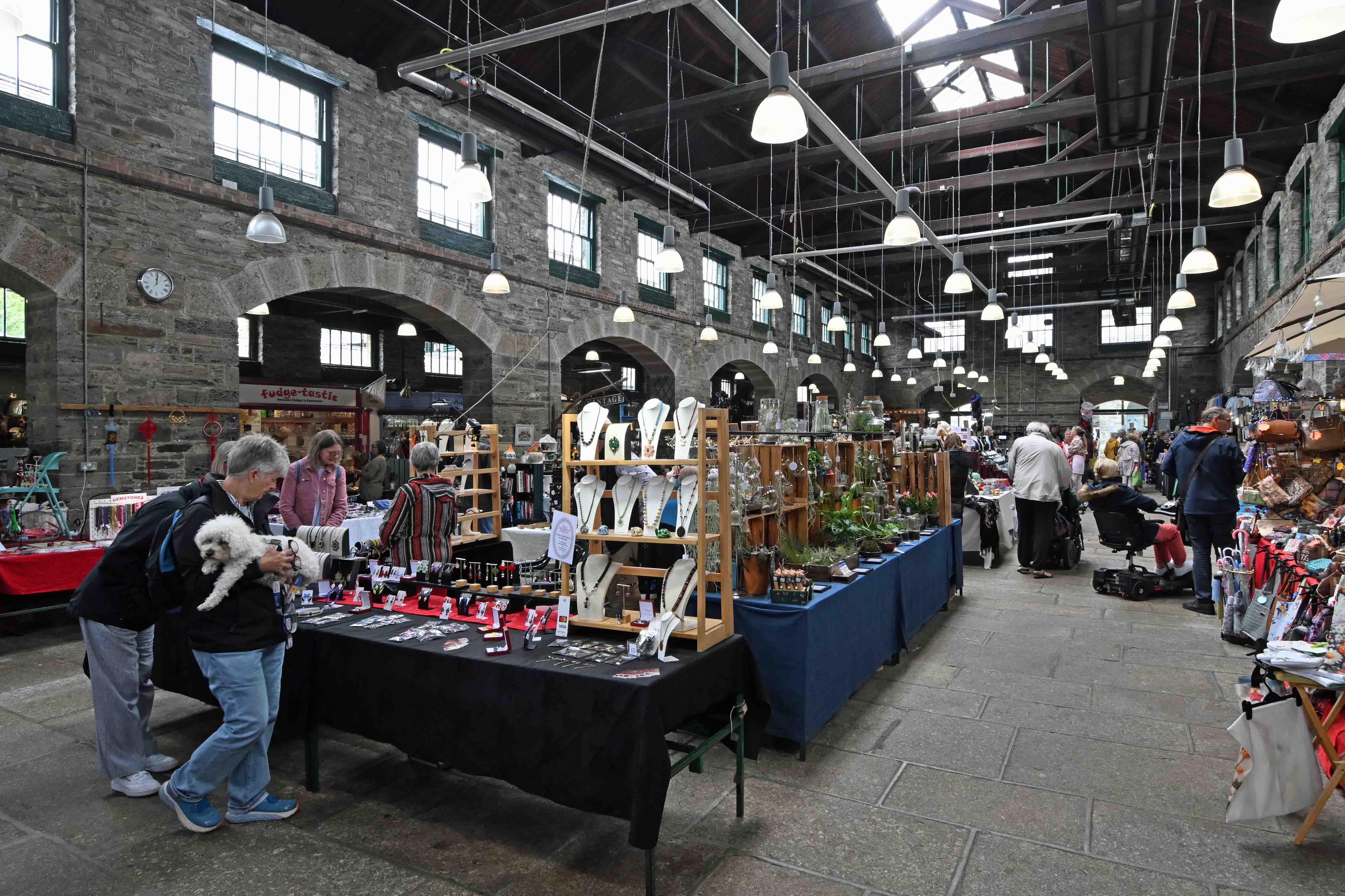
Our third day in Devon was less about trekking and more about touring – although we still managed an old railway walk! Clive drove the three of us over to Tavistock, a lovely old town neither Dawn nor I had ever visited before. Tavi’ has a fantastic indoor market which is well worth a visit. It certainly separated us from some money!
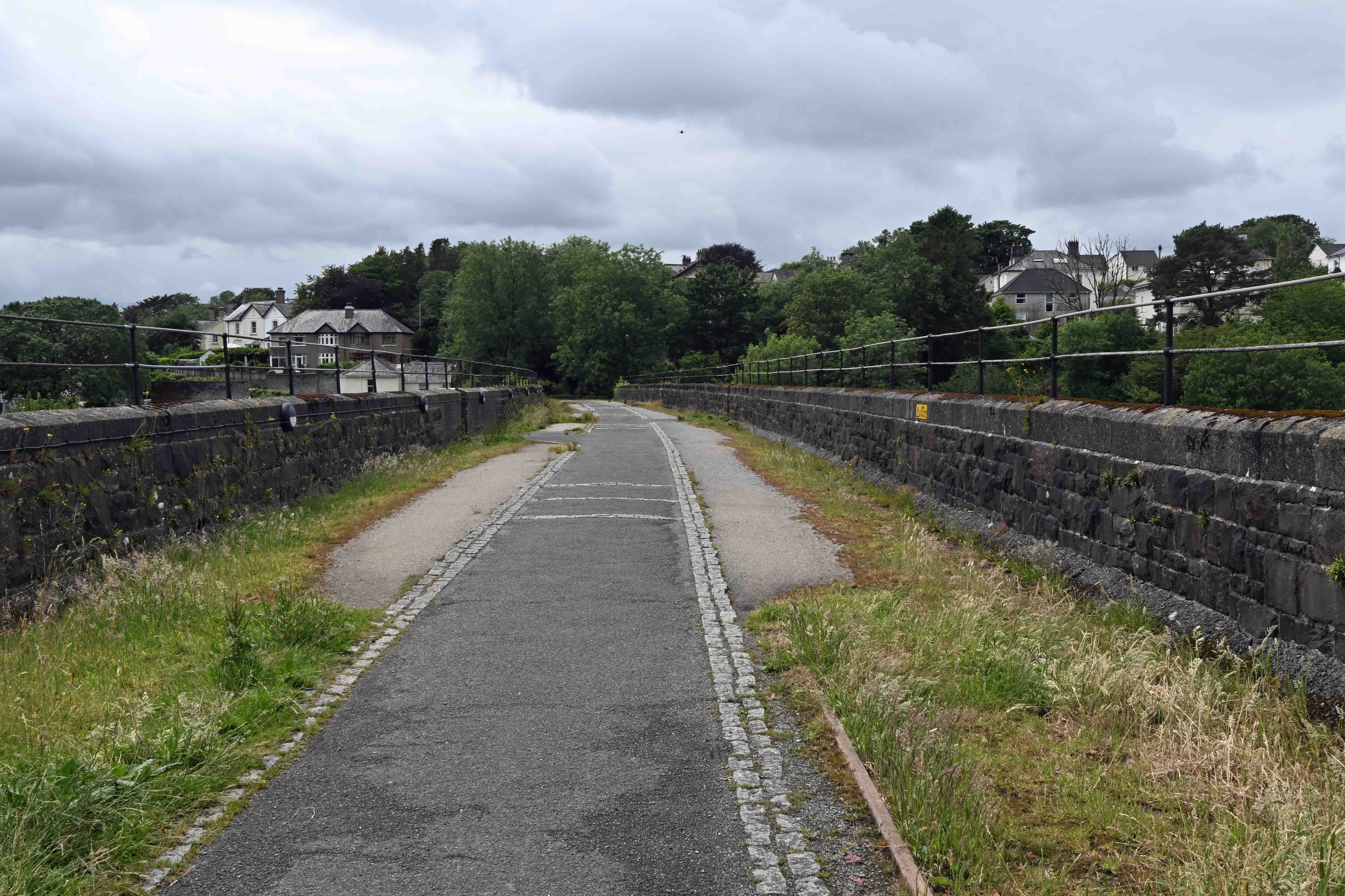
Tavistock once had two railway lines serving the town. Both have been closed. Tavistock South was on a line from Plymouth owned by the Great Western Railway whilst Tavistock North was part of the London and South Western Railway. The LSWR was built above the town, which it crossed on on a high viaduct. This is now part of a cycle and walking trail which offers good views across town.
Moving on from Tavi we had a tour of Dartmoor which is reminiscent of North Yorkshire. After which we called in at Okehampton, where the town was restored to the national railway network in 2021. Here’s a few pictures from our travels…
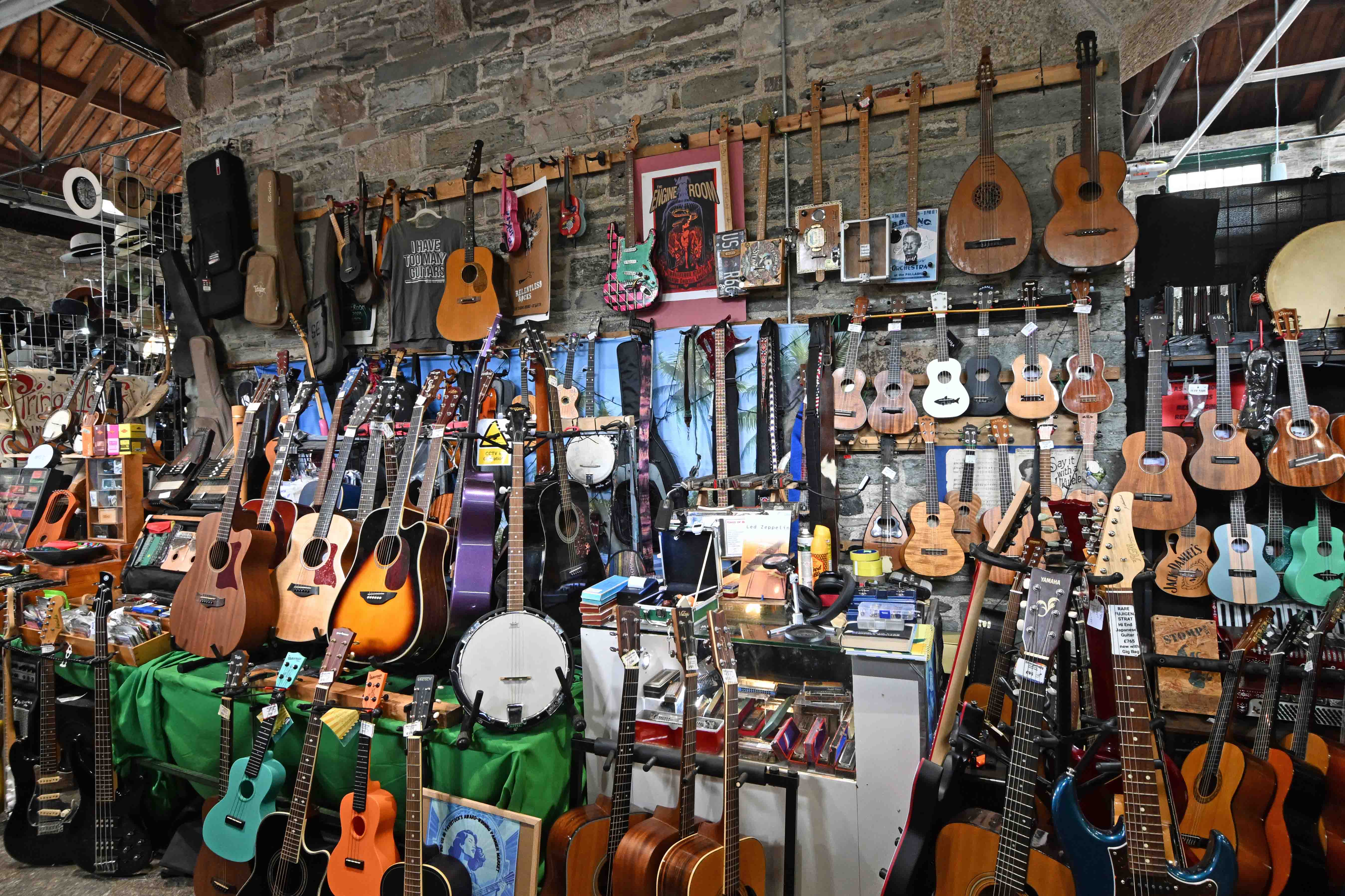
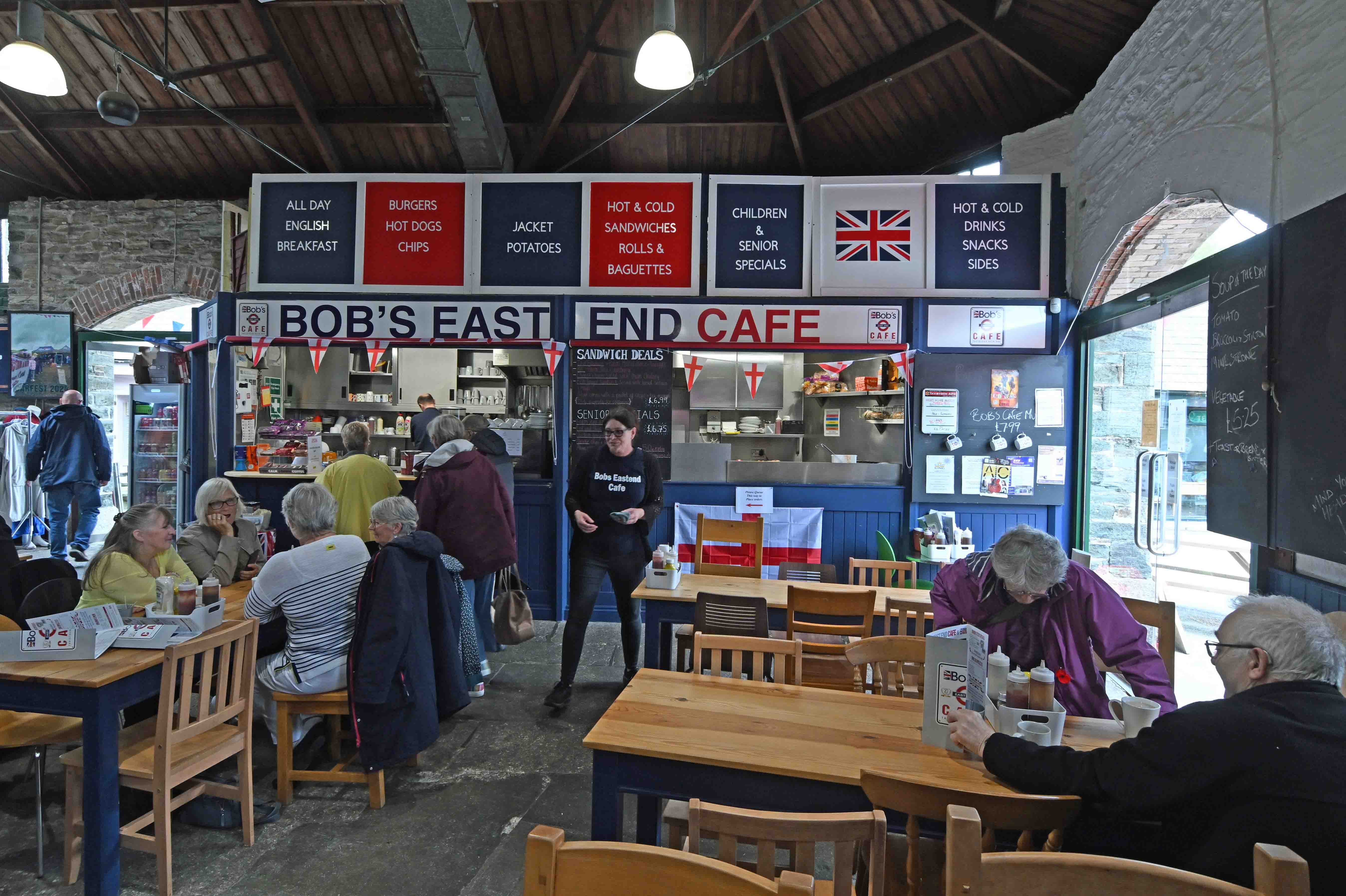
Inside Tavistock’s Pannier market. There’s a great selection of stalls selling all sorts of stuff, old and new…Need a guitar or ukulele?Bob’s East End cafe in the Pannier market. A great place for an all day breakfast at very reasonable prices. The LSWR viaduct in central Tavi was completed in 1890. It’s 420ft (128m) long and is made up of eight spans; five of 50ft (15m) and three of 32ft, (10m) with a height of 70ft (21m) to the road below. The old station is behind the camera but access is restricted as it’s now a private dwelling.The view from the viaduct looking over town. Walking along the old line. The trackbed has been raised in many places. – hence the low height of the overbridge. Dartmoor. You can see why they built a prison up here…Okehampton station has been restored and repainted in Southern railway colours, although…The Great Western Railway had the last laugh as the current train service to Exeter is operated by the GWR franchise – until it’s absorbed into the nationalised Great British Railways anyway…
I’ve a small favour to ask… If you enjoy reading this or any of the other blogs I’ve written, please click on an advert or two. You don’t have to buy anything you don’t want to of course – although if you did find something that tickled your fancy that would be fab! – but the revenue from them helps me to cover some of the cost of maintaining this site (which isn’t cheap and comes out of my own pocket). Remember, 99% of the pictures used in my blogs can be purchased as prints from my other website – https://paulbigland.zenfolio.com/
Day 2 of our trip saw us on another long walk whilst visiting some historic places with rich social histories. Clive drove us to Westward Ho! the only place with an exclamation mark in its name. The name came from a Charles Kingsley book, titled Westward Ho! It was a best seller and brought a new wave of tourism to the Bideford area leading to the creation of the village, which has grown considerably in recent years.
Our walk took us along the coast on the trackbed of an old railway that I’d never heard of before. This was pretty unique too as it’s possibly the only standard gauge passenger railway that was never connected to the national network. The Bideford, Westward Ho! and Appledore railway had a very short life. It opened in 1901 and closed in 1917. Having walked along part of its route along the cliffs I’d have thought it would have made a great preserved railway and tourist attraction, but it never survived World War 1.
The course of the old railway makes a great coastal path. Here it is at Abbotsham Cliffs West of Westward Ho! At this point the old railway swung inland to head towards Bideford. You can see the course of the line and a couple of breaches in the trackbed near the top of the picture. This is a lovely place to stop and admire the coastline. The wind was whipping up quite a few white capped waves during our walk. Here’s the view looking East towards Baggy Point.
Back in Westward Ho! We explored the village and I discovered its link with one of Britain’s most famous authors whom I’ve long admired. Rudyard Kipling. Kipling went to school in Westward Ho! and he’s remembered by plaques and a line of his most famous poem ‘if) being incorporated into the seafront pavement.
Memories of Kipling in Westward Ho!A colourful row of houses in Westward Ho! with several being repainted for the summer season.
Having driven back to Northam we popped into the local church where Ann volunteers at their regular coffee and cake days. I’ve always enjoyed visiting country churches as they often provide fascinating glimpses into British social history and St Margaret’s was no exception. Oh, and the cakes were excellent!
Many a well-to-do family’s line ended like this during the First World War, with the death of the only son.Segregated church services!Coffe with Passionfruit and lemon cake. Yum!
Having returned home to take our ease I couldn’t resist on last wander into Bideford to make the most of the weather in order to get a few pictures.
The most substantial surviving structure of the old railway is the engine and carriage shed in Bideford. Nowadays it’s used as a car-wash. The old bridge in Bideford with the modern bridge in the background.
I’ve a small favour to ask… If you enjoy reading this or any of the other blogs I’ve written, please click on an advert or two. You don’t have to buy anything you don’t want to of course – although if you did find something that tickled your fancy that would be fab! – but the revenue from them helps me to cover some of the cost of maintaining this site (which isn’t cheap and comes out of my own pocket). Remember, 99% of the pictures used in my blogs can be purchased as prints from my other website – https://paulbigland.zenfolio.com/
Yesterday, Valentine’s day – and for one day only, the weather decided to give us a break from continuous and monotonous rain. Mind you. it had dumped several inches of snow on the high ground, just to make things more interesting! That said, where we live in the Calder valley was just too low to be in the snow line. We could see the stuff on the high ground on the opposite side of the valley, but we had barely a sniff. That worked to our advantage…
Saturday began with clear blue skies and the sort of weather that – after weeks of rain- made you itch to get out. But where to go? Having perused maps and looked at where the snow lay we decided to drive out South, through Ripponden and across the M62 motorway in search of higher ground. We found what we were looking for at Moss Moor, off the A672 to Oldham where you’re over 450m above seal-level and there’s nothing stopping the wind anywhere. Even on a hazy day you can see the city of Manchester miles below. On a good day you can pick out the Lancashire coast.
Leaving the car we headed off South along the Pennine way. Here’s how the world looked…
Looking out over Moss Moor, which is the origin of the river Tame apparently.Wind conditions in such an exposed location led to some great photo opportunities, where the grass had literally frozen, then was backlit by the low sun. Dawn strolling through the snow towards the White Hill Trig pint (466m). Believe it or not, the M62 motorway’s just out of shot to the right. Conditions underfoot where ‘interesting’. The fresh snow and drifts were easy to walk in but every so often you hit an area that had been stripped bare by the wind so that you were walking on sheet ice. Looking across to Close Moss and Marsden (beyond). There’s a very long railway tunnel under here – somewhere…
Having had our fill of the high moors we decided to head back via Baitings reservoir, which was a regular entry in last year’s ‘reservoir blogs’. Here’s how it looked in August last year.
See the modern bridge beyond the old bridge? It’s here, in the distance. This is how full and overflowing the reservoir is today, with snow on the surrounding hills that will add even more water.
Sadly, the weather’s reverted to type. Today we’ve had grey skies and intermittent rain, a pattern that we seem to be stuck with. Never mind. Bugger the weather, tomorrow I’m having another day out to head over to Manchester and Southport in order to look at two very different events…
I’ve a small favour to ask… If you enjoy reading this or any of the other blogs I’ve written, please click on an advert or two. You don’t have to buy anything you don’t want to of course – although if you did find something that tickled your fancy that would be fab! – but the revenue from them helps me to cover some of the cost of maintaining this site (which isn’t cheap and comes out of my own pocket). Remember, 99% of the pictures used in my blogs can be purchased as prints from my other website – https://paulbigland.zenfolio.com/
With New Year behind us and the weather remaining cold but turning sunny we felt it was time to work off some of the festive food by heading out to explore a new walk. Looking at our options I plumped for another water walk, this time around the Digley reservoir near Holmbridge in the Holme valley, near the well-known town of Holmfirth (the setting for the long-running TV series ‘last of the summer wine’).
The drive over to Digley takes about 45 minutes cross-country, which isn’t bad, although the closer we got the more ‘interesting’ the country roads became due to a mixture of shallow snow and black ice which was cunningly hidden in the shadows. Digley is actually two reservoirs, with the smaller Bilberry up above it.
Bilberry has an interesting history. It was the original of the two, and in 1852 it burst, spilling 86 million gallons of water down the River Holme, causing 81 deaths and a large amount of property damage. The disaster caused a change in the way dams were built from then on.
In contrast, Digley wasn’t opened until 1954, despite being planned in the 1930s. The waters now cover the site of two mills and a pub, amongst other buildings. Here’s how the area looked in 1915.
There plenty of car parking at either end of the dam. The walk’s very pleasant as it passes through woodland and also dips and climbs as the well-maintained paths don’t follow the reservoir edge too closely so you get a variety of views. Here’s a few pictures from our trip.
Looking down on Digley with the dam in the distance. Looking down on the Digley reservoir from Greaves Head. The edge of the Bilberry dam can be seen at the very right hand edge of the picture. As you can see, there’s some gorgeous views across the Holme valley from here. Looking back the opposite way from the dam itself, with the large and ornate dam drain in the foreground (which isn’t open to the public, for obvious reasons).
There’s nowhere to buy food or drink near the dam, so bring your own. However, the Fleece Inn in nearby Holme does food and a range of real ales and other drinks.
I’ve a small favour to ask… If you enjoy reading this or any of the other blogs I’ve written, please click on an advert or two. You don’t have to buy anything you don’t want to of course – although if you did find something that tickled your fancy that would be fab! – but the revenue from them helps me to cover some of the cost of maintaining this site (which isn’t cheap and comes out of my own pocket). Remember, 99% of the pictures used in my blogs can be purchased as prints from my other website – https://paulbigland.zenfolio.com/
Today, the weather Gods smiled upon us! When we woke and looked out on the world (well, the Long Mynd) we saw clear blue skies and sunshine, with visibility clear for several miles. It wasn’t a day to waste, so as soon as we’d scoffed some toast washed down with coffee we donned our walking gear and headed down into Church Stretton. After a brief stop to pick up some goodies from Steele’s family bakery (their chocolate brownie is excellent, as is the fruit flapjack) we headed up to the Burway before striking off across country to follow the town brook path uphill.
Not a place you want to get trapped on in winter.The town brook burbles adjacent to the footpath towards Long Synalds – on the lower sections anyway, after that, the footpath begins to gain height. – as this view shows! Here, we’re looking back towards Church Stretton with Caer Caradoc on the horizon and the Devil’s Mouth in the mid-distance. Having made it up to 425 meters we swung round to the South side of Townbrook valley in order to get to look back over the valley and towards the North. Looking back down over Church Stretton with Caer Caradoc to the left. One of the ‘wild’ horses that can be found wandering the Long Mynd. They’re not actually wild, but the area is common grazing land.Looking West across Yearlet towards Long Synalds. This time of year the colours are amazing as all the bracken is dying back. Dawn atop Ashlet just before we began our descent to Ashes Hollow and the footpath towards Little Stretton. What a contrast in weather, we’d have been in cloud level with zero visibility if we’d been up here over the past few days! Considering it’s nearly mid November temperatures were a balmy 12 degrees, with very little wind. Almost there! We’ve followed Ashes Hollow and the stream to the edge of Little Stretton. This house is the first sign of human habitation, but still within the area managed by the National Trust.
Having been walking for several hours we made a welcome pitstop at the Green Dragon pub. This friendly little pub serves a good selection of real ales and decent ‘pub grub’. I treated myself to the scampi (because it’s not something I’d cook at home) whilst Dawn plumped for the fish and chips.
Scampi, chips and peas with Tartare sauce. I felt I’d earned it!
Fed and watered, we continued our walk back into Church Stretton and home via another pitstop in our ‘local’ the Kings Arms. Now we’re back at the ranch, relaxing and wondering what tomorrow will bring. This Shropshire sojourn is coming to an end, we leave in the morning to head back to West Yorkshire, but the weather forecast is promising torrential rain for most of the journey – bar a small window in the morning that we may be able to make the most of en-route. Let’s see what happens…
I’ve a small favour to ask… If you enjoy reading this or any of the other blogs I’ve written, please click on an advert or two. You don’t have to buy anything you don’t want to of course – although if you did find something that tickled your fancy that would be fab! – but the revenue from them helps me to cover some of the cost of maintaining this site (which isn’t cheap and comes out of my own pocket). Remember, 99% of the pictures used in my blogs can be purchased as prints from my other website – https://paulbigland.zenfolio.com/
Today’s been a good one here at Bigland Towers. Dawn was up early to travel to Holmfirth for a Reiki treatment whilst I stayed at home and caught up on some work, then gardening. The weather’s taken a change for the better here in the Pennines. Whilst we’re not back into heatwave territory the sun has made a welcome return, which has made all the difference.
This afternoon we decided to take time out and explore part of the area we’ve never walked before. This was the moors West of the Warley Moor Reservoir (which is home to the Halifax sailing club) onto Midgeley Moor, . The views up here are really good. You can see for miles in most directions. This time of year the heather is just springing into bloom which adds even more colours to the landscape.
Here’s a few pictures.
Looking East from Midgeley Moor. In the middle distance you can see the sails of yachts and sailboards on the reservoir whilst in the background are the wind turbines on Ovenden Moor.The footpath we traversed follows a catchwater drain which is crossed by several old stone bridges like this.Taking a break on the moors.
Having walked several miles we retraced out route back to the car to drive down the other side of the hills to nearby Oxenhope where we called in at the Bay Horse Inn, a lovely little pub which we’ve passed several times before but never visited. Today we put that omission right. They serve a great selection of well-kept real ales which you can quaff outdoors in their large seating area at the front of the pub. It’s a lovely sun-trap where you can watch the world go by.
Now we’re back at Bigland Towers, having a quiet night in and putting our (tired) feet up. Tomorrow’s weather’s looking good so we’re planning to catch up with a few chores before getting out again before the working week starts again. Watch this space…
I’ve a small favour to ask… If you enjoy reading this or any of the other blogs I’ve written, please click on an advert or two. You don’t have to buy anything you don’t want to of course – although if you did find something that tickled your fancy that would be fab! – but the revenue from them helps me to cover some of the cost of maintaining this site (which isn’t cheap and comes out of my own pocket). Remember, 99% of the pictures used in my blogs can be purchased as prints from my other website – https://paulbigland.zenfolio.com/
Today, after a busy morning at home sorting out various chores we decided to abandon Bigland Towers and make the most of the cooling weather to get out for a walk and explore somewhere new. The state of the counties reservoirs is a hot topic as we’re one of the few places with a hosepipe ban – despite the fact you can’t walk far in Pennines without falling over a reservoir!
We decided to drive up the the hills above Walsden and Mytholmroyd, where the Calder valley snakes around the moors and head for a trio of catchments, namely the Warland, Light Hazzles and White Holme reservoirs.
But first we stopped off at a location we’d visited the other week. Baitings Reservoir (at the bottom right of the map), where the level has dropped a good 2-3 feet since our visit on the 7th. The old bridge in the picture has become quite a tourist attraction!
Heading on up the hill we parked the car on the road down to Cragg Vale before heading off along one of the dirt roads that form much of the walk, which isn’t strenuous as the area is actually pretty flat. The area’s popular with dog walkers, but that brings me on to a real gripe. The gate from the main road is a dumping ground for bags of dogshit. I mean – why? Do these people believe in the existence of a poo-fairy, who will magically remove them because they’re too lazy to dispose of them or don’t want their precious cars contaminated?
Take it home with you – or don’t have a dog. Why should the rest of us have to put up with yours and your dog’s mess?
First stop was White Holme reservoir, which – was only down by a few feet, not bad compared to some. The levels left these little beach areas exposed, which would have made a pleasant place for a picnic.
Next was the Light Hassles Reservoir, a narrow body of water that bridges and connects the other two bodies of water. This seemed to be at its normal level.
Before heading on to the third and final reservoir we took a detour to admire the views, which would be superb on a clear sunny day, because you can see right across to Manchester – and beyond. En-route to the viewpoint we passed a few dozen cows which were grazing or drinking, supremely unbothered by the odd human walking past, disturbing their idyll.
Cows ignoring us and the views, with the skyscrapers of the city of Manchester visible on the horizon. Hollinwood lake in the foreground, the warehouses of Milnrow in the middle-distance and the city of Manchester on the horizon. I’d love to pop back here on a clear sunny morning to see how the view looks.
Having taken time to soak up the scenery we continued on to the last reservoir – Warland, which was suffering from the lack of rainfall.
That’s a lot of missing water!
This particular reservoir was bult in the 1850s by the Rochdale Canal company to ensure a ready supply of water to keep the canal across this part of the Pennines open. It was extended in the 1920s by Rochdale Corporation Water Works, who left their mark with stonework like this.
We really enjoyed the walk, which covered around 4 miles. We’d loved to have explored more (Stoodley Pike is only a short walk away) but we’d run out of time. Instead we headed home via Cragg Vale and a couple of drinks in the always welcoming Robin Hood pub where I managed to make the young lady behind the bar’s day. She spotted my camera which I lent it to her for a while so that she could have a play after she’d knocked off work. Having studied photography she was delighted to be able to muck around with such a serious piece of kit. I love being able to do that!
The heatwave is due to end this next week with rain predicted on Tuesday. I doubt it’s going to make much of a difference, so expect more reservoir blogs over the summer…
I’ve a small favour to ask… If you enjoy reading this or any of the other blogs I’ve written, please click on an advert or two. You don’t have to buy anything you don’t want to of course – although if you did find something that tickled your fancy that would be fab! – but the revenue from them helps me to cover some of the cost of maintaining this site (which isn’t cheap and comes out of my own pocket). Remember, 99% of the pictures used in my blogs can be purchased as prints from my other website – https://paulbigland.zenfolio.com/
Today we decided to eschew our usual walking locations around West Yorkshire for a change of scenery by venturing further (but not too far) afield. The recent gales had smashed some plant pots in the garden and to replace them like for like we had to visit a garden centre near Holmfirth, so as we were in that neck of the woods we chose the nearby Langsett reservoir as a suitable place for a stroll. It’s surrounded by pine woods and has a pub and cafe in the village nearby, so all the right boxes were ticked.
It was a walk we really enjoyed because of the contrasts. Here’s how it looks on Ordnance Survey maps.
Having left the car in the (free) Yorkshire Water carpark we headed West along the woods at Langsett bank on the North side of the reservoir. There’s some impressive pine trees along the path. Mere striplings they ain’t!
At the far end we crossed over an attractive stone arch bridge then explored a short distance along the little Don river which feeds the reservoir. I spotted these interesting rock formations along its banks.
Rock sandwich anyone?
Doubling back on ourselves to the bridge we then began the climb along the South side up onto the moors at Hingcliff common which offer great views across the area. The heather’s in flower at the moment, which adds extra colour to the scene.
The rest of the walk took us along well defined paths back down to the reservoir and through the woods which border the Southern side as far as the dam itself. These allow access to the water’s edge, where we were surprised to see just how low the water levels were. Considering we’ve had such a wet Spring and Summer we were at a loss to understand why water levels were so low.
Looking back to Langsett (on the left side of the dam) and the dam itself.
Back in the village we stopped off for a well-earned drink at the local pub, the grade 2 listed Waggon and Horses, which dates from 1828. The pub serves real ales (Abbeydale Moonshine and Timothy Taylors Boltmaker were on today) as well as food and it also has a beer garden which partly overlook the reservoir. The size of the pub’s deceptive, as it’s a lot larger on the inside than it first appears, having several rooms. It also offers accommodation.
We certainly enjoyed the change of scenery and we were lucky with the weather, which has been unpredictable to say the least. Tomorrow we’re expecting traditional bank-holiday conditions. Rain!
I’ve a small favour to ask… If you enjoy reading this or any of the other blogs I’ve written, please click on an advert or two. You don’t have to buy anything you don’t want to of course – although if you did find something that tickled your fancy that would be fab! – but the revenue from them helps me to cover some of the cost of maintaining this site (which isn’t cheap and comes out of my own pocket). Remember, 99% of the pictures used in my blogs can be purchased as prints from my other website – https://paulbigland.zenfolio.com/
Today we decided to blow a few cobwebs away and head out for a hike to a place we’ve never walked up before – Pendle Hill, over in Lancashire. We know the area reasonably well as we had a friend who lived in nearby Clitheroe who we used to visit, but we’d never ventured up the historic hill. As we’ve been looking to try walking somewhere different for a change we thought ‘why not’?
The area’s just over an hours drive from where we live in West Yorkshire, with some great scenery on the way – a mix of wooded valley and old industrial revolution heritage. Our first port of call was the village of Pendleton, which nestles at the foot of the hill. It’s a pretty, historic little village with a cracking pub called The Swan with Two Necks.
The Swan also has a large beer garden (and marquee) at the rear of the pub.A selection of Lancashire and Yorkshire beers of varying strengths including a stout – plus a cider.
The Swan has an excellent selection of real ales and good pub grub. It’s very popular with walkers and tourists visiting the area, so if you’re planning to eat booking is essential.
Having refreshed ourselves we drove back as far as the Nick of Pendle on the Clitheroe Rd where there’s parking adjacent to the path which will take you to the summit of the hill. This is a longer walk than most, but it doesn’t suffer from the steep gradients that the shorter routes do. It also offers some fantastic views en-route.
There’s a rather poignant memorial at the start of the path which is dedicated to two world war 2 airmen (one Australian, one American) who lost their lives when their planes crashed on the hill.
Here’s a few pictures from the walk.
Dawn posing for the camera as we began our walk to the summit. The view from the summit, looking over Black Moss Reservoirs with the towns of Nelson and Colne beyond. Walking back down to the Clitheroe road with Blackburn hidden behind the hills.
Now we’re relaxing at home, resting tired knees and associated muscles before another active day tomorrow – although one that will be very much home-based.
I’ve a small favour to ask… If you enjoy reading this or any of the other blogs I’ve written, please click on an advert or two. You don’t have to buy anything you don’t want to of course – although if you did find something that tickled your fancy that would be fab! – but the revenue from them helps me to cover some of the cost of maintaining this site (which isn’t cheap and comes out of my own pocket). Remember, 99% of the pictures used in my blogs can be purchased as prints from my other website – https://paulbigland.zenfolio.com/
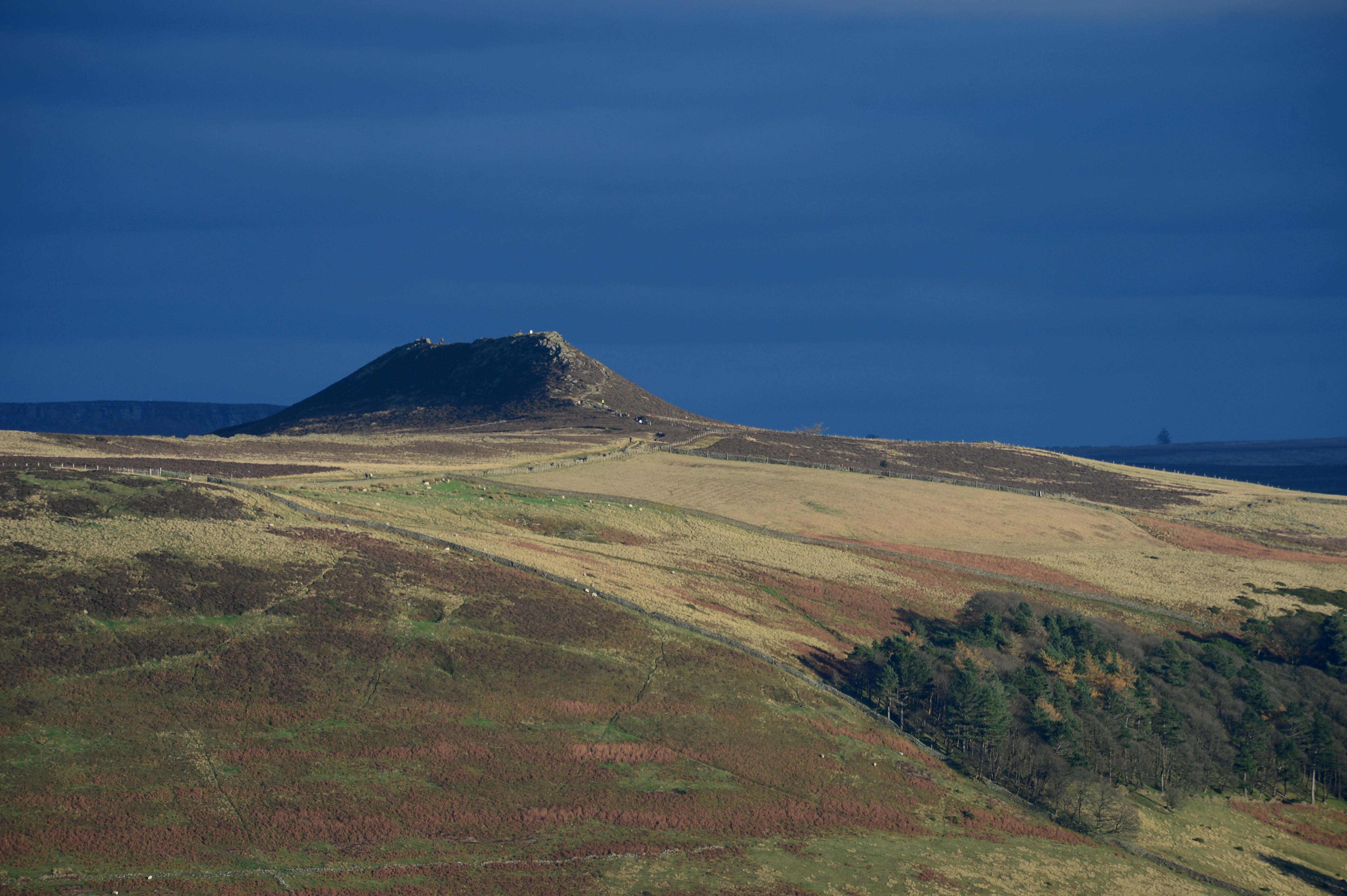
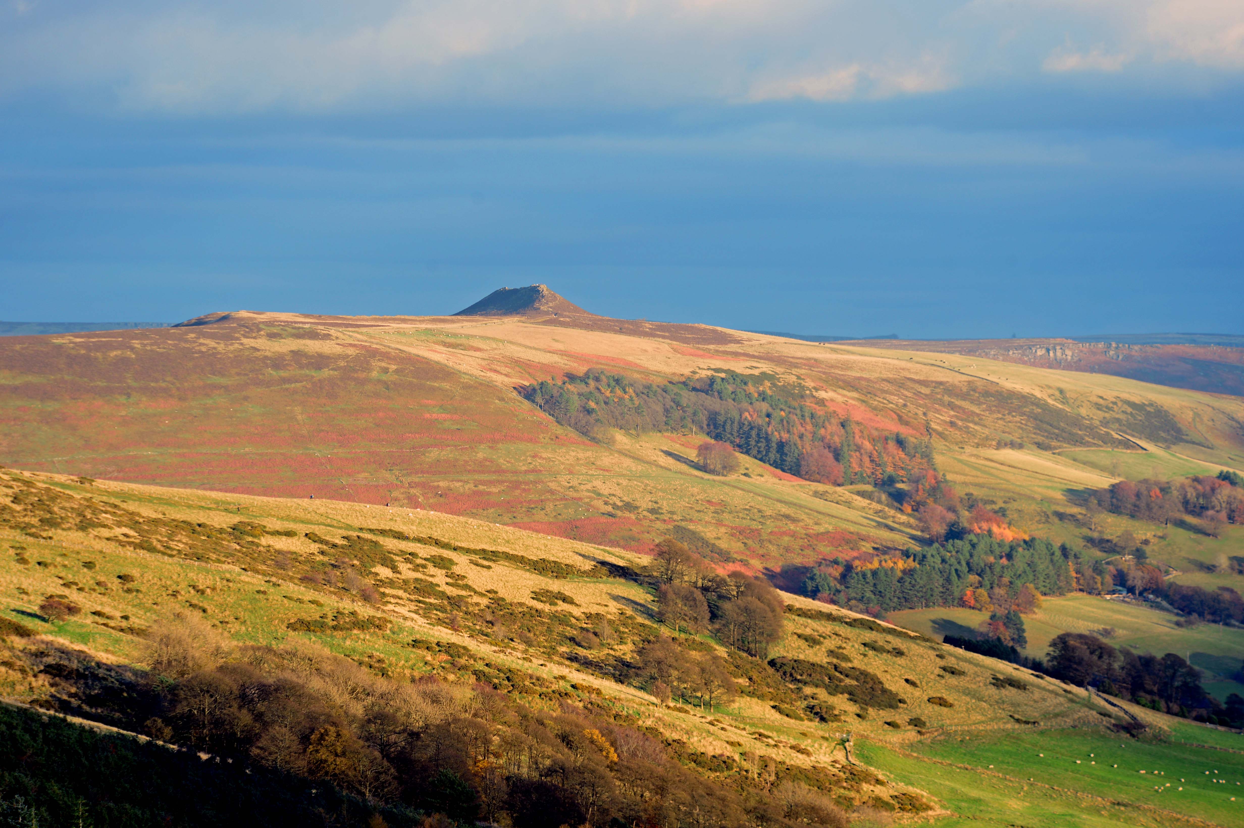
As promised by the weather forecast Saturday turned out to be a bright, crisp and sunny day – so the pair of us tore ourselves away from computer screens and headed over to the Hope Valley in Derbyshire for an afternoon out walking somewhere where we’d been promising to revisit but had never got around to doing so. The 517m high Mam Tor and the ridge Eastwards to Lose Hill along the South side of the valley is a wonderful (if at times challenging) walk. The views South across the Hope Valley and North across Edale are sublime.
With the weather being so good the area was teeming with walkers and it was great to see so many people of all ages and backgrounds enjoying walking. Oh, and not to mention the paragliders who were also out in force! The skies above the ridge were teeming with them as they drifted lazily on the winds.
Here’s a few pictures from the day.
The ridge affords some excellent photograph opportunities to capture shots of trains passing through Edale between Manchester and Sheffield. Here’s a Trans-Pennine Express service made up of units 185103 and 185123 working.1B79, the 1226 Cleethorpes to Manchester Piccadilly. Northern trains run the only local stopping service. Here’s one of their Class 195s working 2S72, the 1349 Manchester Piccadilly to Sheffield passing the base of Lose Hill. The autumn colours and low light in Edale were stunning. Walkers descending Lose Hill on their way East into the Hope Valley with the railway curving away in the centre of the picture. The edge of the village of Castleton can be seen to the right.This is the 463m high Win Hill seen Eastwards across Edale from Lose Hill along with some rather moody skies on the horizon.The same view from Mam Tor and zoomed out to show the landscape and colours in slightly different light.
All the high-res versions of these pictures can be found (and purchased) from my Zenfolio website by following this link.
Sadly, I don’t think I’m going to be getting out to do much exploring like this over the next week. Instead, I’ll be glued to a screen at home writing for a living. Not that I’m complaining as there’s a damn sight worse ways of earning a living, and if I get lots of type-swiping done quickly, who knows what I might be able to get up to later in the week?…
I’ve a favour to ask… If you enjoy reading this blog, please click on an advert or two. You don’t have to buy anything you don’t want to of course (although if you did find something that tickled your fancy that would be fab!), but the revenue from them helps to cover some of the cost of maintaining this site – and right now (because of Covid), us freelances appreciate all the help that we can get to aid us in bouncing back from lockdowns. Remember, 99% of the pictures used in my blogs can be purchased as prints from my other website – https://paulbigland.zenfolio.com/