
Tags
I’ve never bothered blogging about High Speed UK before. Mainly because the project has no hope of ever getting off the kitchen table it’s been drawn up on.
However, researching yesterday’s blog on the waste of time that was the Yorkshire StopHs2 ‘conference’ in Wakefield threw up something interesting. It was this comment on the Erewash Stop Hs2 groups Facebook page;
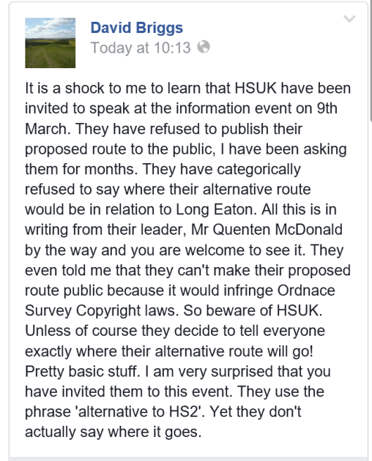
They can’t make the route public because “it would infringe Ordnance Survey copyright”? Really? That’s not what Ordnance Survey say. Here’s the link to the OS website page, which says;

So, that’s HSUK’s claim blown out of the water by the OS!
Of course, there IS another reason why HSUK aren’t keen on using OS maps to overlay their pretty lines on. It becomes obvious when you have a look at the maps they have on their website. Here’s part of the map for West Yorkshire.
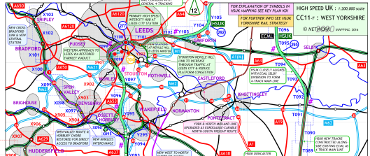
As you can see, it’s devoid of detail. Human habitation is drawn in the vaguest of ways and there’s bugger all topographical detail either. Now, let’s examine this in more detail against satellite imagery used by Google Maps. Let’s take Wakefield as an example, seeing as the conference was there yesterday. HSUK propose a new Western chord linking the ECML at Wakefield Westgate with the lower level line through Kirkgate. But what’s actually in the way of such a chord? Well, you won’t find any detail on HSUKs map – and here’s why!
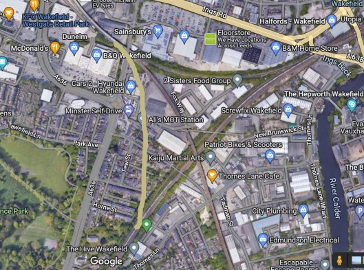
What HSUK aren’t keen for anyone to see it that chord would cut right through an industrial estate, across Waldorf Way, then pass straight through a housing estate which includes Avondale St, Tew St, Cotton St and Horne St! Can you imagine what the citizens of Wakefield might have said if they saw this map on display yesterday? Would the Erewash and Yorkshire Stophs2 groups be so keen to support HSUK if they knew details like this? I think we all know the answer to that – there would be uproar from their members at the magnitude of demolitions and disruption – which is why HSUK (unlike Hs2 Ltd) don’t use OS maps!
Of course, publishing this level of detail would expose their claims that HSUK would be £20bn cheaper to build than Hs2 as the moonshine it is. None of these demolition/compensation or other costs are factored in.
Now, let’s have a look at the answer to David Briggs question about Long Eaton. Here’s the HSUK ‘map’.
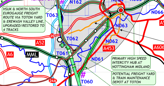
Notice those tunnels to the South of Long Eaton? Where would be the construction site for them – or the entirely new line heading South. Let’s have a look at Google again.
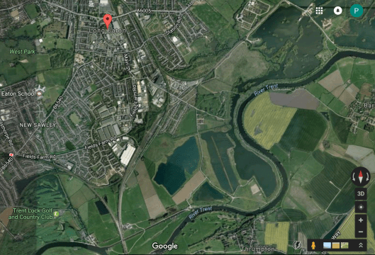
Hang on a minute – where have those lakes come from? They’re not shown on the HSUK map. Only the river Trent is. I wonder why? Could that be because those lakes are actually Trent Windsurfing Club, who might not be too happy about this? Oh, and the other side of the Trent is Thrumpton, where Thrumpton Hall is set amongst 300 acres of parkland! Only it’s right in the way of HSUKs little scheme!
The more you compare HSUK’s featureless maps with what’s really on the ground, the more obvious it becomes why HSUK don’t use OS maps. It would kill support for their madcap scheme stone dead.
I do hope some Long Eaton residents see this and get to ask HSUK some rather frank and awkward questions on the 9th – as well as the stophs2 campaigners who’re in bed with HSUK. I may disagree fundamentally with the StopHs2 campaign, but I believe that people who live along the route have the right not to be misled or used as pawns by others with their own agenda.
I’ve a small favour to ask…
If you enjoy reading this or any of the other blogs I’ve written, please click on an advert or two. You don’t have to buy anything you don’t want to of course – although if you did find something that tickled your fancy that would be fab! – but the revenue from them helps me to cover some of the cost of maintaining this site (which isn’t cheap and comes out of my own pocket). Remember, 99% of the pictures used in my blogs can be purchased as prints from my other website – https://paulbigland.zenfolio.com/
Or – you can now buy me a coffee! https://ko-fi.com/paulbigland68312

Little wonder that HSUK seem so reluctant to give details of their intended route.
I’m still trying to work out why they’d want to demolish half of the new development in Nottingham, including a rebuilt station, to build a new station….
The evidence for this claim is what? Hs2 isn’t passing through Nottingham, so this claim is rather far-fetched to say the least.
Your reference to being misled is a bit rich coming from you. Have you personally read HS2’s economic case? If you have, you might have an opinion about it omitting the bulk of the costs.
Yes, I have read it. I notice your assertion isn’t backed up with a shred of evidence (a familiar pattern with those who oppose Hs2). You claim the ‘bulk’ of the costs have been omitted, so your evidence for this claim is what? Hs2 has been under scrutiny for years. By the Transport Select Ctte, The Treasury Select Ctte, the National Audit Office, the Lords Economic Ctte, the Major Projects Authority and the Treasury themselves. Why do none of them support your claim? Simple. because it isn’t true.
Well, you walked right into that little trap didn’t you Mr Bigland. You really should be more careful what you cut and paste from discussion forums. It makes you look even more of a prat than your usual posts suggest. Perhpas when you’ve ‘moderated’ this, you can tell everyone what the capital finance provisions are for HS2? You moight then maybe tell everyone what you understand the term ‘released capacity’ to mean? How about identifying one single business with plans to expand or employ more people as a result of hS”? Apart, of course from the orange jacket mob and the odd trainset maintenence shed. Even HS2’s Regional Director Mr. Paul Griffiths admits that the jobs created will only be construction jobs, and likened it to the revamp of New Street Station in Birmingham. There, of course the local economy benefitted from construction consumers, and then it disspated when the project was completed. You might also ask The East Midlands Chamber of Commerce (who, oddly support HS2) where the new jobs will come from. They admit to me in writing that they don’t know where any economic benefits from HS2 will come from in practice.
So, blog that you ignorant prick.
When did silly abuse and making stuff up ever stop Hs2? All it does is show why little groups like yours are bound to fail – and why your local MPs writes to all her constituents warning them of the disinformation that groups like yours put out.
The capital finance provisions for Hs2 come from HM Treasury and the Chancellor. Hs2 is a Govt funded project and the money has been agreed in The Govts budget expenditure.
Released capacity has been explained at length in the Economic case for Hs2, by Network Rail, the Dft (and many others). It’s a firmly established and well understood fact. That you choose to ignore it is by the by.
Your comment that only the ‘orange jacket mob’ will benefit from Hs2 is, quite frankly, laughable. That’s why it’s contradicted by all the business organisations, LEPs, Chambers of Commerce, local authorities and all the other sources that you ignore because they contradict you opinion.
As for the claim about Paul Griffiths, that’s also laughable, as is your assertion that New St only created construction jobs. Anyone who’s visited the Grand Central shopping centre that was built above the station might notice that there’s actually rather a lot of people employed by it who are wearing anything but orange and hard hats (unless John Lewis has suddenly changed their staff uniform recently). For a start, there’s this http://www.birminghammail.co.uk/whats-on/shopping/john-lewis-grand-central-birmingham–10099113 and this. http://www.birminghammail.co.uk/news/midlands-news/recruitment-campaign-fill-1000-jobs-8670204
You’re a classic example of why local Stop Hs2 groups are doomed to failure. You simply make stuff up that doesn’t stand up to the simplest scrutiny. It’s no wonder that your MP warns against you. If you try this nonsense on in the petitioning process the lawyers and genuine experts will demolish you in 5 minutes.
The only people who can stop the Hybrid Bill process are MPs. As they’re overwhelmingly in support of Hs2 (as are all three major political parties) – as are the House of Lords, you’re wasting your time – just as the Nimbys on Phase 1 wasted theirs. Instead of arrogantly thinking you can stop a national infrastructure project just because it impinges on you, you’d be far better of trying to make it work for you by trying to maximise the benefits it can deliver. There’s a large pot of money attached to Hs2 for that very purpose. Sensible folk are already eyeing that pot, others who come to the table late because they’ve wasted all their time opposing Hs2 lose out as the money’s already allocated. I can see which group you’re going to be in.
Unfortunately, laughable as you consider my remarks to be, they are sadly quite true. I had a very long discussion with Mr Griffiths at a public consultation event only last month. He hadn’t read his own company’s economoc case either! It was actually Mr Griffiths and HS2 media relations officer Lindsey Preece who gave the New Street Station comparison, not me.
Regrading ‘released capacity’, this as you should know, is HS2’s name for ‘cuts to existing rail services’. Their economic case goes into some considerable detail (the section headed ‘assumptions’, and names those stations that will experience such cuts. They quantify the contribution to the cost of HS2 by released capacity as being £8.3 Billion. Their figures, not mine of course. Mr Griffiths was unaware of released capacity (as was the MP for Erewash until I gave her the references to it).
As for those inconvenient omitted costs that you find laughable, these comprise mainly of the capital finance costs (the bulk of the actual cost to the nation) and the compensation costs to those who would lose their houses or land as a reult of the route.
You will presumably be aware of the Benefir-Cost Ratio (BCR) that HS2 present to the public? This shows that for every £1.00 of cost, there will be over £2.50 of benefits. The problem of course is that it is calculated on the construction costs only (the figure you HS2 folk like to use, the £60-70 Billion odd amount). Once the omitted costs are added (and unless some fairy godmother is going to pay, the nation will do), then HS2 is a classic example of how to lose money big time.
So you see, you really do have to grasp the facts that Hs2 themselves present. You might like to tell your blog audience where the money is coming from for HS2 and how much it will cost to borrow it? Then tell everyone who is actually going to pay for it?
You will find, as I did via FOI Requests and discussions with HM Treasury that the money will have to be borrowed from foreign financial institutions. At the same rate of interest as we pay off the national debt (for example) this will be by far the largest part of the cost of HS2 (much more than the construction costs that you like so much). Anyone born last year (2016) will be approaching retirement age when this foreign debt is finally repaid. So, unless that fairy godmother has a deep purse, I am all ears for you to ridicule these facts too.
Funnily enough, I am not instinctively opposed to High Speed Rail. I became interested initially from an environmental point of view. After realising the misleading information coming from government about that, I studied in fine detail the entire HS2 economic case. This too I found to be full of selective assumptions, ommissions and frankly, downright deceit. So my approach is not that of yours, a rail nut and one associated with somne of the main culprits, I simply look at what HSW2/government themselves are saying and writing. Anyone can do that of course, otherwise we all argue like you do.
Have a fine day.
Still trotting out the same ignorant comments I see. Thanks for showing why your campaign is doomed to failure – and always has been.
I note you repeat the claim that there will be £8.3bn ‘cuts’ to existing services to fund Hs2. That lie was exposed years ago. I’ve explained it here. https://paulbigland.blog/2015/02/19/more-on-the-rukin-rumpus-with-added-slides/
For ‘cuts’ read savings on operations – over a timescale of 60 years! There are no “omitted costs”. The costs of compensation are already contained in the Hs2 business case and budget. Yet again, all you do is show just how dishonest you are.
It’s no wonder your local MP has warned her constituents about the disinformation coming out of your group. Point 29 in this document refers to compensation. https://www.gov.uk/government/uploads/system/uploads/attachment_data/file/286797/financial-case-hs2.pdf In fact, Hs2 has already recouped £9.1m in rental income! http://www.thetimes.co.uk/article/hs2-earns-5m-renting-out-houses-dtn9jh9mr
As for this nonsense about FOI requests to ‘discover’ the Govt borrows money abroad. This merely shows a lack of any knowledge of Government finances. It’s common knowledge to anyone with the slightest understanding of the working of Govt finances that Govts borrow from a number of sources, including abroad. Where on earth did you think it got the money from – down the back of the Chancellor’s sofa? Meanwhile, borrowing money when interest rates are at historic lows to invest in infrastructure is no bad thing. Moreover, the pictures is nothing like as simplistic as you make out. Much Govt borrowing is in the form of ‘gilts’ – and it’s often UK institutions like pension funds and insurance companies that buy them – as this old BBC news item explains. So, please, spare us the nonsense that this is only ‘revealed’ by your FOI requests! http://news.bbc.co.uk/1/hi/business/8530150.stm
You also claim that the BCR is calculated purely on construction costs. Again this is either you showing complete ignorance of the truth, or a deliberate attempt to deceive. Here’s how the BCR is calculated https://www.gov.uk/government/uploads/system/uploads/attachment_data/file/480718/hs2-west-midlands-to-crewe-sobc-economic-case.pdf 1.13 onwards exposes your claims as utter rubbish.
Still, thanks again for helping to expose the dishonesty and misinformation we’ve come to expect from groups like yours and why anyone with an ounce of sense steers clear of them – including your MP. You can kid yourself with this rubbish as long as you like, but it won’t impress those who make the final decision on Hs2 – MPs. They’ve already found you out.
You flatter yourself Mr Bigland. Probably why you have such a large audience. The simple truth is that the capital finance costs are the bulk of the cost to the nation regarding HS2. As such, to choose to ignore them or hide them speaks for itself.
By the way, would you like to buy my car? I’ve not actually bought it myself yet, so bear with me on how much it will cost you. The car has 4 wheels and is silver/grey in colour. I can’t really tell you any other details about it. If you can pay me anyway that would be great thank you.
No-one is ‘hiding’ or ‘ignoring’ anything. The fact is, you don’t actually know what you’re talking about. Nothing can be ‘hidden’ as any of the bodies that oversee public finances and projects (such as the National Audit Office, The Public Accounts Ctte, The Transport Select Ctee – or their counterparts in the Lords – or the Major Projects Authority) would be screaming blue murder. Not a single one of them is.
Your MP was absolutely right to write to her constituents and warn them about your group as it’s very clear that you just make stuff up – which is why you’ll fail. No-one with any sense or responsibility will listen to you and you’ll be given short shrift in the petition hearings. Hs2’s legal counsel will tear your dishonesty to pieces.
Like i say, next time I need mortgage I must ask you where you get free money from.
FOI Requests do throw up some odd things. Ask where the finance for HS2 is coming from and the reply comes from HM Treasury saying ‘we have no information about the content of your request’. However, they do include links to Governement Debt Management, the Gilt market and (oddly) a website recruiting apprentices to work at HS2. I knew I should have asked Mr Bigland.
It always amuses me the way Hs2 antis waste their time trying to dig dirt on Hs2. They’ve tried it ever since 2010. Where’s it got them? Nowhere. There’s no ‘smoking gun’ to find. Half the time they don’t even seem to understand the answers they get! Meanwhile, Hs2 moves on apace…
I would have thought a ‘democrat’ like you would have faith in the FOI process. Obviously not. As for ‘digging up dirt’ as you seem to think anything you don’t like is, have you heard of someone called Andrew Jones? He’s hit the big time in a letter to me recently. All I did was ask him why compensation costs were omitted from the Benefit-Cost Ratio that HS2/Government are using. He told me that these costs are included in the land and property cost used in HS2’s economic case. They may well be. But the land and property cost aren’t included in the BCR calculation.
Amazing isn’t it? They stand up and spout about the benefits of HS2 when they don’t even understand the details of the case they present. He actually went on to write ‘we do not publish the overall cost estimates for compensation’. Yet he says those costs are included in the economic case, that is ‘public’.
For the benefit of your other reader, Andrew Jones is the under-secretary of state for transport.
This is hilarious! Truly, you don’t even grasp the fact you’re making a complete fool of yourself here. The BCR is not separate from the economic case for HS2. It’s a crucial part of it. So, of course the land and property costs are included in the BCR – as part of the construction costs! HS2’s lawyers are going to make mincemeat of you if you’re daft enough to try this one on! Instead of wasting your time on silly FOI requests you should talk to people who actually know something about all this – especially as all the information is in the public domain. It doesn’t need your daft FOI requests to find it (I can only assume you like playing juvenile ‘cloak and dagger’ games, pretending that you’re uncovering ‘secrets’ when you’re actually just wasting everyone’s time – including your own). They’d have told you how pointless this is. They’d probably have pointed you in the direction of the High Speed Rail (preparation) act of 2013, which specifically deals with property purchase and compensation! Honestly, I can see why your MP was so keen to warn about not believing anything that your silly groups says.
I’m afraid you are mistaken. The land and property cost are not part of the construction costs included in the BCR calculations. Your reactions is rather typical (I might use it in another dialogue to illustrate a point or two). The FOI system isn’t intended to be ‘silly’ as you put it, of course. Indeed FOI has caused a few stirs in the HS2 ranks of late. You actually sound a bit irritated. This could have something to do with the recent ‘ship jumping’ by certain HS2 executives and a slight re-concentration of the HS2 issue by a few MPs.
I wonder who you suggest it is best to talk to? Economists or railway nuts? Or maybe Mr Grayling (I assume you agree with him on matters about HS2, he of course is highly qualified on these things), or even some of your fellow trainspotting geeks who call themselves ‘journalists’ (my 12 year old niece takes photos of trains sometimes too).
Oh, and the MP you refer to (Ms Throup, MP for Erewash) is having a rather sweaty change of heart about HS2 and will be actually be involved in the StopHS2 Erewash issues a bit more closely from now on.
Finally, it’s a good job nobody is reading your blog because the link you kindly include is out of date on the issue of land compensation and property purchase. This resulted from the process in the House of Lords led by Lord Berkely.
Keep trying, you might get a few more readers after I’ve finished with you.
You really are very funny. As usual, you don’t offer a shred of evidence for any of your assertions – what a surprise. Still, feel free to provide hard evidence that the land and property costs aren’t included in the construction costs. We both know you can’t – which is why you never do. As for your MP having a ‘change of heart’, that would be the same MP who warned all her constituents about your campaign’s dishonesty, wouldn’t it? You might be able to bluff, bluster and try to deceive on social media, but as I’ve pointed out before – the petitioning process is a legal process. Hs2’s Lawyers will make mincemeat of you. There’s not a cat in hell’s chance that you can stop Hs2. You don’t have anything like the political clout. You’re a tiny local group in a campaign’s that’s collapsed on the national stage. Still, these daft claims of yours will make a good addition to a ‘how not to campaign’ guide when Phase 2 goes ahead.
I’m perfectly happy to debate the economics of HS2 with you face-to-face on any public forum by the way. Now, that’s a challenge you should enjoy. I certainly would and I promise not to spit the pips out too far after I’ve made a meal of you.
You flatter yourself far too much. The economics of Hs2 are clearly way out of your league. But I do find it funny the way you waste so much time on a subject that won’t stop hs2 coming through your area in the slightest. That’s a decision that will be made by MPs debating in the Houses of Parliament, not by a tiny, clueless, pressure group. If you’d any sense you’d be directing your efforts at looking at mitigation and compensation. Instead, you re-run the same failed Nimby focussed campaign that never stopped Hs2 in the Chilterns – and they had far more money and expertise than you ever will. You’re doomed to failure on so many levels, partly because of your own hubris. Meanwhile, the more sensible folk will already be looking at bidding for the money in the compensation/mitigation pot – which will probably be empty by the time you finally come to your senses – if you ever do…
I take that as a cowardly refusal to debate with me then? Don’t blame you actually. You already sound like a twat and I would only be indulging myself proving the fact. Still, the offer is there and people are probably watching you avoid it.
What debate? You peddle opinionated rubbish and abuse. That’s not debate. I’ve repeatedly provided the facts (with links to authoritative sources) that show what nonsense it is that you’re talking. You’ll be lucky to last as long as it takes to get to the petitioning stage. If you do make it that far you’ll make complete fools of yourselves as you’ll be up against people with knowledge and facts with nothing more than bluster and insults. You’re so far out of your depth that I almost feel sorry for you. You don’t even seem to understand what it is you’re getting involved in.
Meanwhile, all your comments on here do is prove what arrogant and unpleasant people are involved in your futile campaign.
The problem you have is that nobody is reading this. I’m giving you an opportunity to publicly discuss what you know about HS2. Then I will rip each piece of uninformed nonesense you trot out to shreds with the facts. Let’s see which of us looks the fool eh? Pity I’m not a gambling man otherwise I’d bet you that HS2 doesn’t get built.
I’ll leave you to your obvious delusions, but thanks for stopping by to show why your campaign’s more of an ego-trip than a credible attempt to do anything about Hs2.